Units
Taukkunen Kaserne
This is the first page of photos and layout of the Kaserne. The second page shows more contributed by Howard Thomas as well as the history of the kaserne going back to the 1890s.

As shown in the color photo sent by Al Ferrara (HHC-1-48 1962-4), Co A is the building in the center rear, with the B Co. building on the left. In front of B Co. is the recreation center (pool tables, etc.) The building to the right rear of the flagpole was the church. Note the flag at half mast, as this photo was taken 2 days after the assassination of President Kennedy. The B&W photo on the right was taken the day after the assassination; note the flowers at the base of the flagpole left by the local Germans. Both photos were taken from the 4th Floor of the HHC Co. building. The one of the far right belonged to a Transportation Company that was stationed there also. Taukkunen Barracks were in the city, northeast of the main railroad station on Mainzer Strasse between Petrus-Dorn and Bensheimer Strasse, with the main entrance of Pfortenring Strasse.
The layout below was made possible by Jack Falcone,

Two pictures of Peter in the Kaserne, left by H/H Co, and right on the parade ground with the EM Club on the extreme right.


The pictures on this page were sent by Howard Thomas and were taken in 1960-62). Below them are a history of the barracks, links to a map of the post and what it looks like now.


History
 Depending on whether the Germans, French or Americans were occupying Taukkunen Barracks, it had many names; Prince Carl Anlage, Caserne des Vallieres, Kemmel Kaserne, Foch Caserne, or Taukkunen barracks.
The barracks were built for the 2nd Battalion of the German Kaiser’s 118th Regiment of Infantry "Prinz Carl" * (Grand Duchy of Hesse No. 4, or 4th Hessian Infantry Regiment ) which was posted to Worms in 1836. *Prince Carl (Karl) of Hessen and Rhine (1809-1877) was a general of the infantry.The first billets of the unit were not built for military use, were cramped and hygienically precarious as well. The city of Worms started negotiations with the military administration in 1884 to improve the situation. By 1987-1900 the first fourteen main buildings of the kaserne were completed.
This 1889 postcard contributed by Robert Sheridan shows the "new barracks" in the upper left corner. They were known as the Prinz Carl barracks after the Regiment. With the outbreak of WW I the regiment went immediately to  the front.
 This photo at left is of a member of the regiment, Freidrich Kellner who was called up for active duty in 1914 as a sergeant and deputy-officer.
After their departure a “Landwehr” regiment was set up in the barracks.
After the end of the First World War French troops, in accordance  with the Versailles Treaty, occupied Worms and the barracks from 1919 to 1930. The French gave the barracks a new name: "Caserne des Vallières".
After the departure of the French troops in 1930 the Rhine country was to remain demilitarized under the Treaty, and the barracks were open to use by the city. The city rented different buildings for use as a shelter for homeless people and badly accommodated families. In April 1931 the city bought up the entire east part of the barracks convenient to Altmuehlstrasse and made them dwellings for homeless people, as were the chamber building in 1933. Beside these dwellings, there were occasionally also the security police and the SA office in the kaserne. Just prior to World War Two, four more large buildings were completed on the west side by Gaustrasse and Bensheimer Strasse and a small one in the northeast corner. During the Second World War it was renamed Kemmel Kaserne, but was only of minor importance. 
In 1945 toward the end of the war parts of the barracks were removed for defense positions against the US Army. However they were not used for that purpose because of the fast retreat of the German armed forces resulted in no combat. During bomb attacks on February 21,1945 and March 18, 1945 Kemmel Kaserne was the target. However within the barracks only small destruction resulted, and predominantly the surrounding civilian area was bombed.
French occupation troops were again stationed there starting in the middle of 1945 and this time they gave it the name “Foch Caserne”. In the autumn 1951 the French troops were replaced with American troops.
The Americans added seven more significant structures, and an Officers’ Mess pictured below. The name "Foch Kaserne" remained to October 1956. Then, per USAREUR order 201 its was renamed in honor of Staff Sergeant Ernest Taukkunen of the 41st Armored Infantry Regiment , 2nd Armored Division.  Taukkunen post became an important communication center of NATO troops in Europe . On January 4,1967 it became headquarters COMZEUR (United States Army Communications zone Europe ), responsible for the supply for American troops in Germany. COMZEUR was previously accommodated in Orleans, Belgium, Holland and Great Britain. This unit was supplemented with an extensive communication infrastructure of the USAISC-Europe (US Army Information Systems Command, Europe) later redesignated as the including a large radio antenna. American troops left in 1996. And the Kaserne was again vacant for civilian use.
Today, in the buildings of the former barracks after renovation/modernization, moved in offices among other things the euro school, the engineer’s office hydraulic plan, possibly a telephone call center from the tourism industry.
LOCATION OF THE BARRACKS
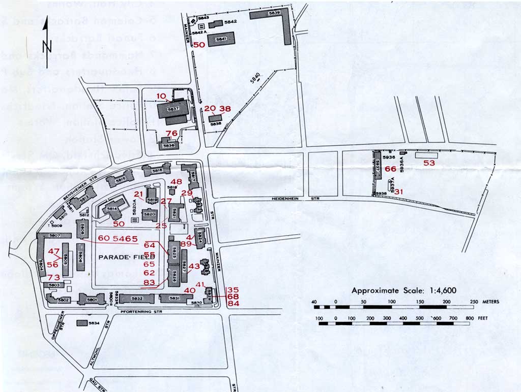
For a map of the Kaserne go to:
http://www.usarmygermany.com/Communities/Worms/Taukkunen%20Map.jpg
Taukkunen barracks lies north of the center of the city of Worms . The main railway line Mannheim-Mainz and highway B9 lead directly past the area, and the main train station is nearby. The Taukkunen barracks is an attractive location to both the city center, the trade and industrial areas of the north, and the surrounding green areas. The immediate area of the barracks contain parks, housing and roadways as well as industrial areas. The land occupied by Taukkunen barracks is rounded in the west by railroad tracks, marshalling yards, sheds and auxiliary buildings. In the north beyond the Bensheimer road is a multi-story residential zone. Trade and industry are beyond that. East the area is a mixed housing area and multi-family houses built around 1900, and Liebfrauenkirche church after that. In addition the port area and the Rhine follow in less than 1000 meters. South the area follows the former city hospital area land development area and the Albert-Schulte Park which is a "green axle" to the city area and to the station.